
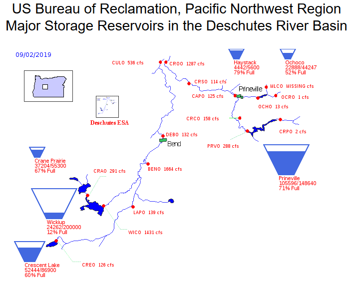
Irrigation season in Central Oregon continues into mid October, but the picture is already an interesting one. As this graph makes obvious, many local “lakes” are actually irrigation reservoirs and local rivers are used as irrigation canals. What is also obvious is the difference between water levels in Wickiup and other reservoirs.
These reservoirs are controlled by the US Bureau of Reclamation and local irrigation districts. Many of these districts are composed of a small percentage of what would commonly be called farmers or ranchers, i.e., people who grow crops or livestock, the sale of which provides a significant source of their income. Most irrigation district “patrons” are hobby farmers or people who simply water the ground to maintain their water rights.
North Unit Irrigation District is the primary exception. NUID surrounds Madras and is composed of what everyone would call traditional agricultural farmland. NUID gets a majority of their water from Wickiup Reservoir. Even after a 25% reduction in water deliveries this season, however, Wickiup is nearly empty and will likely completely drain by the end of the season, just like last year. There are a number of reasons for this, which you can read about here and here.
The difference this year is that NUID managers did reduce deliveries but will still empty Wickiup. Yes, there was a reasonable snowpack last winter, but it melted far too quickly to allow Wickiup to be replenished over the summer.
This poses an obvious and important question. Why don’t high value agricultural farmlands have priority over hobby farms and big lawns? The water in our rivers, reservoirs, and in the ground is owned by the public. Why isn’t the public’s water being used for the benefit of the public?
As readers of this blog know, I have written about these issues extensively, but the graph above is another stark reminder of just how much we need to reform water use and water rights in Central Oregon.
