

Sadly, as I have written about many times, it is irrigation season and once again the Middle Deschutes below Bend is being killed. According to the US Bureau of Reclamation gauge, the Middle is currently flowing at 64 CFS. Prior to the installation of upstream dams and irrigation withdrawals, this section of river would be flowing around 1,200 CFS. Not only are the flows lethally low, they are erratic (see the chart below). The photo above is from a Central Oregon Irrigation District email last month that provided the irrigation startup schedule to their patrons. I was struck by their use of this image, as I will explain below.

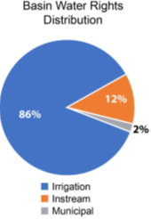
According to the final Upper Deschutes River Basin Study released by the Bureau of Reclamation and the Oregon Water Resources Department, while the public owns all water, irrigators have been granted rights to use 86% of all available water in the Upper Deschutes Basin for their private benefit. (The Upper Deschutes Basin is the area that contains all the water that eventually drains into Lake Billy Chinook). As has been well documented in this blog and elsewhere, per the US Department of Agriculture, this water is often not used in a commercially viable manner, especially in Deschutes County. Water is also distributed in a highly inefficient manner, with water loss rampant through out the system.

The most discussed water loss is from seepage out of canals, a conversation that has been focused on the main canals owned by the irrigation districts. Estimates of these losses can be as high as 50% depending on the specific canal section. At taxpayer expense, these canals are slowly being piped, a process that will take decades.
Coming off the main canals are “lateral” canals which deliver water to individual “patrons”. These canals are mostly privately owned. I am not aware of any comprehensive studies on seepage loss from private laterals, but it logically follows they will have loss rates similar to the main canals. If anything, I would guess loss is higher due to lower levels of maintenance. There are no announced plans to pipe lateral canals in any significant fashion.
Once the water is delivered to a patron, it is applied to the land in any number of fashions, all of which also have associated levels of loss. Still common, and the most inefficient, is the use of flood irrigation. This brings me back to the photo of the “wheel line” irrigation system above. Is this supposed to show an efficient use of water? Studies have shown that in arid, windy climates like ours, up to 45% of the water sprayed out in this fashion is lost before it hits the ground!
So, let’s add it all up, while erring on the side of being conservative. Let’s speculate that there’s only 25% loss from the main canals, along with 25% along the laterals, and then 25% by the patron’s final delivery system. Using those generous assumptions, 100 gallons taken from a river only delivers 42 gallons to a field.
The cost of this incredibly inefficient system in a time of drought and global heating are rivers like the Middle Deschutes on life support. We, the public, own the water. Are we happy with the way in which it is being used?
