

We can now make a prediction about how the Crooked River will look for the remainder of the year. The executive summary is that the Wild & Scenic section below Bowman Dam, where most anglers spend their time, down to the City of Prineville (CoP), will have good flows during irrigation season and will have low, but survivable flows in non-irrigation season. Below CoP is another story. Flows below CoP will be extremely low, lethally so at times, during irrigation season but then improve during non-irrigation season. Read on for a detailed explanation.
Here’s a post that dives into how flows in the Crooked River are managed and another that details irrigation withdrawals, I recommend reading both for background. As recently as a month ago, the snowpack in the Ochoco Mountains provided some water managers with optimism that Prineville Reservoir would fill and the full allocation to both contracted (irrigation) and uncontracted water (for fish) would be met.
A dry and warm spring has dashed those hopes and today the reservoir is only 60% full. The Upper Deschutes and Crooked River Basins are currently at 67% of normal snow water equivalent. Baring a late and enormous snow event, Prineville Reservoir will not fill this year. The “day of allocation” (when the amounts in each bucket are set) is not until the end of this month, but it’s abundantly clear that the fish bucket will not come close to filling. (Remember that the irrigator bucket fills first.)
During irrigation season, water will be released from the reservoir to meet irrigation demands, but essentially all of it will be withdrawn by the time it passes through CoP, the location of the last major diversion. North Unit Irrigation District (NUID) has a diversion below that and when they call their water there will be temporary spikes in flows below CoP but that water will be diverted just above Smith Rocks.
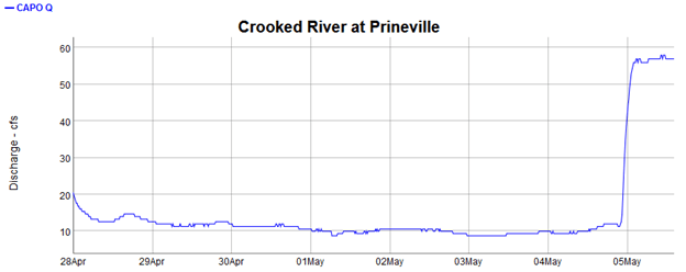
You can see this in the chart above where the PRVO gauge (below Bowman Dam) reads 228 CFS but the CAPO gauge is only at 12 CFS (below CoP). You can also see the variability below CAPO in the graph below. The river has been around 10 CFS (!) for a week but has temporarily spiked up to meet demand from NUID.
Going back to the graph at the top, you will see that flows increase downstream from CAPO, primarily from polluted excess irrigation return flows, until close to Lake Billy Chinook (CROO gauge) when groundwater from springs dramatically recharges the river.
Most anglers are primarily concerned with the Wild & Scenic section, but I would argue that the entire river is important for resident and anadromous fish. 10 CFS, especially in hot weather, will not support fish. Sudden, dramatic swings in flows are also detrimental, stranding fish and stirring up sediment.
The Deschutes Basin Habitat Conservation Plan does have provisions for drought years and preserving flows below CoP, but only during non-irrigation season. In those months, a minimum of 50 CFS is required from Bowman all the way to Lake Billy Chinook. I have no idea why this is not a year round requirement. Also note that the 2004 Crooked River Act sets a target of 80 CFS as a year round target.
