

The Deschutes Valley Water District maintains a spreadsheet that identifies and counts the fish that pass through the ladder at Opal Springs Dam on their way up the Crooked River. It’s pretty interesting to see how many and how many different types of fish use the ladder. I had never even heard of a chiselmouth before seeing thousands of them in the spreadsheet heading up river to spawn in the spring. Anyway, I have been thinking about drought and local river levels and went back to correlate flows with spring chinook returns last summer. It was as bad as I expected.
If you recall, last year saw the highest number of spring chinook released into the Upper Deschutes Basin since reintroduction efforts began. This comes with a caveat, however, as not all of the chinook came from the upper basin. For the first time, many lower river fish captured in the fish trap were put into the upper basin, rather then being released back into the lower river. Nevertheless, the total number of chinook released into Lake Billy Chinook was a record, which should be positive development, but many of them found challenging conditions. Some of the chinook went up the Metolius River but according to the spreadsheet approximately 110 went up the Crooked River from May 23, 2022 until September 10, 2022.
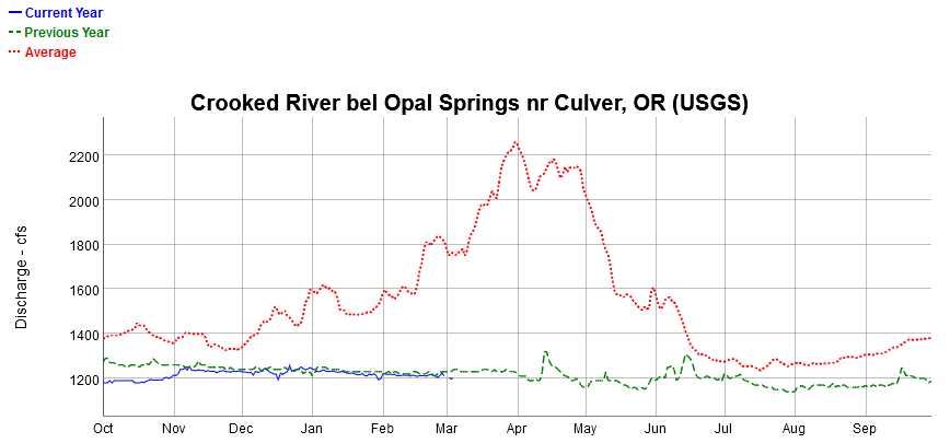
The Bureau of Reclamation has a series of gauges on the Crooked. Moving upstream from the mouth of the river near Lake Billy Chinook, the first gauge is below Opal Springs and shows that flows were well under normal, but they were sufficient for fish to migrate all last year (the green line).
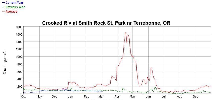
The picture changes dramatically, however, moving upstream to Smith Rock State Park. Flows last year were low enough to impede or block spring chinook migration. At times the flows were under 3 CFS, during extremely hot periods. This is important as spring chinook historically spawned upriver from the park.
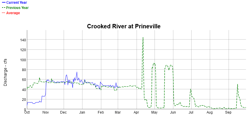
Flows immediately below Prineville got down to under 2 CFS! The extreme variability in flows during the summer were due to irrigation releases out of Prineville Reservoir which were diverted by North Unit Irrigation District above Smith Rocks. So, not only was the Crooked River lethally low and hot, silt was being stirred up and deposited from the abrupt and dramatic changes in flows.
Unfortunately, the odds of providing adequate water for spring chinook to reach their spawning grounds next year are not showing improvement. Even with the recent precipitation, Prineville Reservoir is only 13% full, which is well under normal for this time of year.
