I’m sure you have all been hearing about the end of irrigation season in Central Oregon, the reduction in flows coming out of Wickiup Dam as it is refilled, and the fish salvage operation just above Bend. You probably have not heard about the corresponding havoc on the Middle Deschutes, however.

The graph above is from the gauging station at North Canal Dam on the Deschutes, just upstream from the Mt. Washington bridge. North Canal Dam is where two large diversions draw significant amounts of water out of the river during irrigation season. (Search on North Canal Dam in this blog to learn more.) As you can see, the river is once again going through sudden and extreme fluctuations. The low point was 54 cfs on October 12, the high was 737 cfs 4 days later, followed by a drop to 281 cfs the next day. These dramatic changes stir up sediment, choke spawning beds, and potentially strand fish. There are no salvage operations going on there.
Compare this to the flows as measured just upstream from Bend near Benham Falls and above the fish salvage operation below.
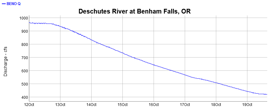
This nice, smooth drawdown was negotiated as part of the Habitat Conservation Plan and intended to limit the number of fish stranded. It used to be a massive drop in a single day. The thinking was that a slow drawdown would allow the fish to leave declining side channels. The HCP does not cover the Middle Deschutes, however, so the irrigation districts make no effort to smooth flow changes in that stretch of river. It’s still just an irrigation ditch.
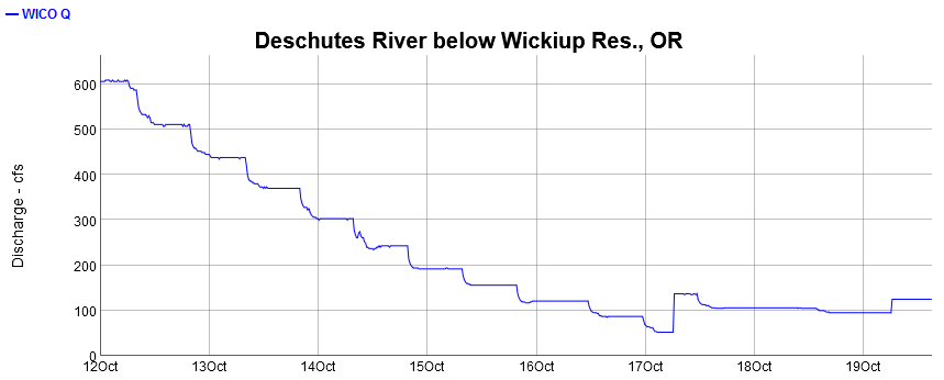
Below is a graph of the flows coming out of Wickiup. Note that it is less smooth than the graph below Benham Falls. This is due to water being added to the Deschutes from the Little Deschutes River, Fall River, Spring River, etc., and smoothing things out. These inflows also explain why the 100 cfs coming out of Wickiup turns into about 400 cfs by the time the river reaches Bend.