Spring brings the beginning of irrigation season in Central Oregon. Irrigation districts usually start water deliveries around April 15 and ramp up to full delivery around May 15. This typically continues until mid-September when deliveries are reduced until mid-October when irrigation season ends. The period 30 day periods at the beginning and end of irrigation season are known as “shoulder” seasons. I think of the spring shoulder season as fish killing season.
It is common to hear that the Deschutes River is being restored by a collaborative process that includes stakeholders including irrigation districts, government agencies, and environmentalists. The truth is more nuanced. While there has been collaboration in many areas, the driving force has been the legal requirement created by the Deschutes Basin Habitat Conservation Plan which requires flows to be increased in the winter from Wickiup Reservoir to Bend. Commonly known as the Upper Deschutes, this stretch is less than one-third of the entire river. The HCP mandated that flows in the Upper Deschutes be no less than 100 cfs, increasing to 400 cfs over 13 years. There is no requirement, or plan, to increase flows in the Deschutes from Bend to where it meets the Columbia River. This stretch is also known to have serious environmental problems.
Today, the Middle Deschutes, from Bend to Lake Billy Chinook, is in worse shape than the Upper Deschutes. Prior to dam construction and irrigation withdrawals the Upper Deschutes would flow at around 500 to 600 cfs near Pringle Falls. The HCP requires it flow at a minimum of approximately 20% of its historical level, increasing to around 67% percent over 13 years. Historically, the Middle Deschutes had flows around 1,600 cfs in Bend after contributions from springs and the Little Deschutes, Fall River, and Spring River. During peak summer irrigation withdrawals flows are reduced to around 125 cfs, about 8% of historical flows.
During spring shoulder season flows fluctuate wildly and can be as low as 65 cfs. That’s only 4% of historical flows. Fluctuations in river levels are sometimes by over 100%, down and up, and can occur in only a few hours. These changes in the spring are lethal to fish and the aquatic ecosystem they rely on.
Flows below Bend are typically at their highest in March then suddenly reduced to their lowest point in the year. Trout are forced to adjust to these considerable changes during spawning season. Frequently eggs are exposed or covered with silt. If spawning has not occurred, trout are forced to seek out new suitable habitat in the drastically reduced and fluctuating flows. More favorable flows and spawning conditions are now upstream of Bend, unavailable to trout due to the lack of fish passage at Mirror Pond dam. Of course, aquatic plants and the insects trout rely on for food are also impacted.
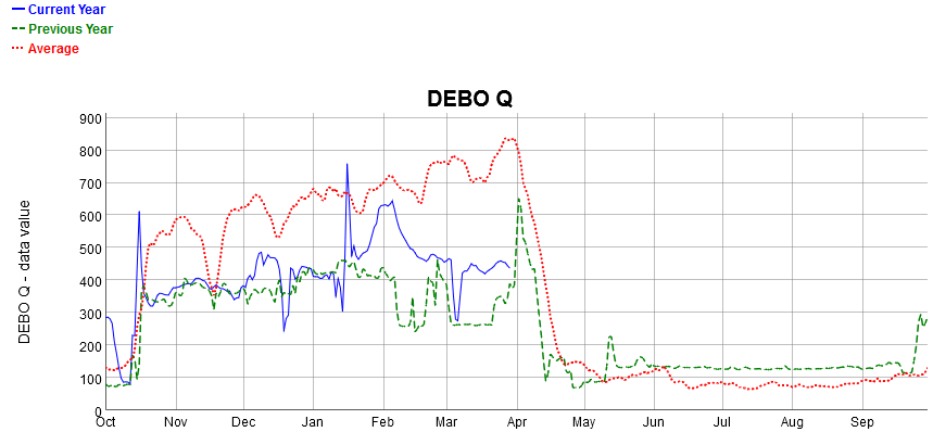
Here is a graph of flows in the Deschutes River at the North Canal Dam which can be found on the Bureau of Reclamation web site.
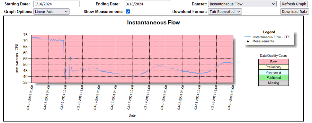
This is not only a problem below Bend. On March 16th Three Sisters Irrigation District dropped the flows in Wychus Creek by almost 50% in only a few hours. For decades, Whychus Creek has been identified as an important component of the attempt to reintroduce spring chinook and steelhead into the Upper Deschutes Basin above Lake Billy Chinook.
Prior to release into Whychus Creek, chinook smolts are placed into a holding pond at the Deschutes Land Trust’s Camp Polk Meadow Preserve. Some water is routed from Whychus Creek into the pond where smolts are acclimated to Whychus Creek water prior to being released into the creek. This year 25,000 chinook smolts were in the pond when the water levels were dropped by the irrigation district, stopping the flow of water into the pond. This is the entire population that was to be released into Whychus Creek this year and approximately half of them died. Unfortunately, this is not the first time abrupt water level changes in Whychus Creek have killed fish raised for reintroduction.
Here is a graph of flows from April 16 through April 18 in Wychus Creek below the Three Sisters Irrigation diversion near Sisters. This is from the Oregon Water Resources Department website.